
The Blip Report for Tuesday, June 18th 2024
The Blip Report for Tuesday, June 18th 2024
Africa and the New World

I was reading a wonderful book by Washington Irving – ‘The Life and Voyages of Christopher Columbus’, and when I got to page 16 [Book 1, Chapter 6] there is a map of what Columbus’s map ‘may’ have actually looked like.
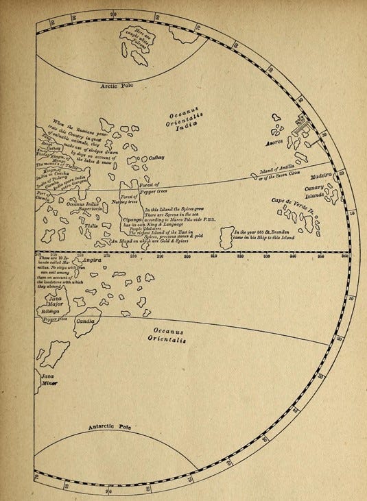
And under the picture it reads: ‘Part of a Terrestrial Globe made at Nuremberg in the year 1492, by Martin Behem’.
“The terrestrial globe, of which a segment is given above, was made at Nuremberg in the year 1492 the very year on which Columbus departed on his first voyage of discovery. Martin Behem, the inventor, was one of the most learned cosmographers of the time, and, having resided at Lisbon in the employ of the king of Portugal, he had probably seen the map of Toscanelli, and the documents submitted by Columbus to the consideration of the Portuguese government. His globe may therefore, be presumed illustrative of the idea entertained by Columbus of the islands in the ocean near the extremity of Asia, at the time he undertook his discovery.”
If we look at the right edge of this globe, the map quite correctly shows the Azores islands, the Madeira islands, the Canary islands and the Cape Verde islands. But it seems to me that everything west of those islands on the Behem [Columbus] map is mumbo jumbo. But then I looked at the island that is a little west of the Cape Verde islands, and it reads –
“In the year of 565 St. Brandan came in his Ship to this Island”.
Now, I’m not sure about the veracity about St. Brandan’s voyages, but I did wonder about his island, and if I had seen that island on another map somewhere. And then I thought about the Piri Reis map. Although this map is claimed by some scholars to have been made in the 15th or 16th centuries, it is nonetheless based on very old maps from antiquity.
And I read a story about one hypothesis that correlates the Caribbean islands and the coast of South America to the Piri Reis map – ‘The mysterious Piri Reis Map: Is this evidence of a very advanced prehistoric civilization?’

And if you are looking at this map of Admiral Piri, then look at an island that is just off of the north-eastern point of what would be modern Brazil. It’s a very distinct and pronounced island, colored in bright orange that looks very similar to St. Brandan’s island in the Behem [Columbus] map. What is this island? Is there an actual island there?
And I think that this is the ‘Island of St. Lawrence’, that was first written about by Amerigo Vespucci, in his letters about his four voyages of discovery to the New World.
[From the ‘Letters of Amerigo Vespucci’, Letter to Lorenzo Pietro Francesco di Medici, on his fourth voyage]
“We departed on the 10th of May 1503, and shaped a course direct for the Cape Verde Islands, where we careened and took in fresh provisions, remaining for thirteen days. Thence we continued on our voyage, shaping a south-easterly course, and as our commander was a presumptuous and very obstinate man, he wanted to go to Serra-liona, in the southern land of Ethiopia, without any necessity, unless it was to show that he was commander of the six ships, and he acted against the wishes of all the other captains. Thus navigating, when we came in sight of the said land the weather was so bad, with a contrary wind, that we were in sight for four days without being able to reach the place, owing to the storm. The consequence was that we were obliged to resume our proper course, and give up the said Serra, shaping a south-west course. When we had sailed for 300 leagues, being 3° to the south of the equinoctial line, a land was sighted* at a distance of twenty-two leagues, at which we were astonished. We found that it was an island in the midst of the sea, very high and wonderful in its formation, for it was not more than two leagues long and one broad, and uninhabited.”
[* Fernando Noronha is probably intended.]

And so, it seems that on the voyage of Captain Goncalo Coelho and the adventurer Amerigo Vespucci, they landed on the Island of St. Lawrence on August 10th 1503 – the feast day of St. Lawrence – that today is called the island of Fernando de Noronha. The question is: did Amerigo also have a map that showed where this island was?
But really, look at how close the coast of Sierra Leone is to the Island of St. Lawrence, and to Brazil. It’s less than half the distance from the Cape Verde islands to the Bahamas, the route that Columbus took. So it’s not a difficult voyage. It would be like a trip of the ancient Egyptians to Carthage, for example. This trip was easily done all the time, as seen in the voyages of Ulysses or Jason.
Anyway, I believe that just as Vespucci, or Columbus, or maybe even St. Brandan, could have made the voyage to the Island of St. Lawrence, the ancient navigators of western Africa also made that voyage - many, many years ago.
And I wondered how that first African navigator would have found where that island was. And all my feathered friends laughed and laughed and laughed, and then said, ‘they would have followed us there, of course, we would have shown them’!!!
And then I read further in his letter, Vespucci wrote:
“We found the island to be uninhabited, supplied with abundance of fresh water, quantities of trees, and full of marine and land birds without number. They were so tame that they allowed us to take them with our hands. We caught so many that we loaded a boat with these animals.”
And a little birdie chirped in, but they wouldn’t have called it St. Lawrence island. What would they have called it, I wondered!
And so, let’s hope that our friends in Brazil and Sierra Leone can share some wonderful stories about this history and hopefully begin some exciting research about the Africa discovery of the New World!
P.S. If Columbus had the Behem map, then when he turned west at Cape Verde, he thought he was headed towards St. Brandan's island. But the map was off a bit and so he arrived at the Bahamas instead. But perhaps if he had the Piri Reis map, he would have gone further south to Sierra Leone, before he turned west, and then he would have arrived at St. Lawrence island, like Amerigo did. Perhaps. But Columbus gets full marks for at least trying.
And a little birdie chirped in, that instead of living in the Americas, we really live in Piri-land.